


The accommodations were excellent and the food was amazing at each destination, a welcome relief at the end of some strenuous days on the trail. I would highly recommend Alpenwild's services and the Haute Route to anyone seeking a wonderful active vacation. - W.P. - Washington
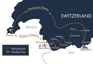
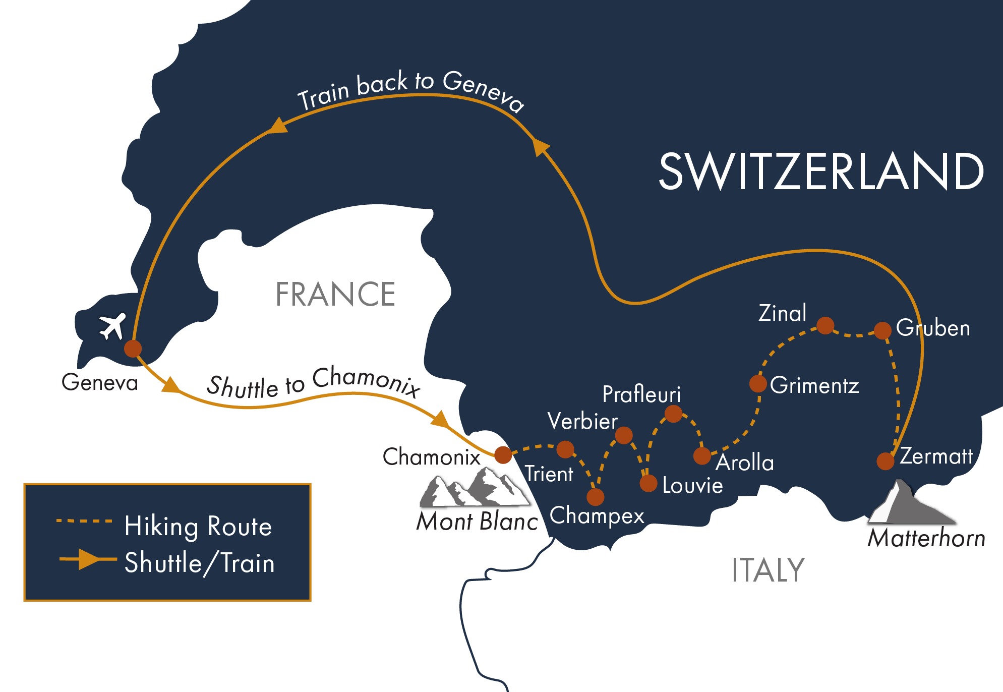
Arrive at the Geneva Airport and transfer by shuttle to the beautiful Chamonix Valley to get acclimated for your trek. Enjoy an optional afternoon excursion to the Aiguille du Midi on the world's highest vertical ascent cable car. Evening in the bustling heart of Chamonix.
Ascent: 200 feet | Descent: 200 feet | Distance: 2 miles (may vary)
Take the morning shuttle from Chamonix to the Col de la Forclaz. From here, ascend Alp Bovine for commanding views of the Rhone Valley below. Continue past lush meadows and woodland into the lakeside village of Champex. (BD - breakfast and dinner included)
Ascent: 2500 feet | Descent: 2300 feet | Distance: 8.5 miles (may vary)
Descend to the Grand St. Bernard valley through quaint farming villages of Orsières and Sembrancher. Arriving in La Châble, take the scenic gondola or bus up the steep incline to the mountainside village of Verbier. (B)
Ascent: 350 feet | Descent: 2457 feet | Distance: 8 miles (may vary)
Today’s route ascends steeply above the Val de Bagnes along the Sentier des Chamois with commanding views extending to the Mont Blanc range. You’ll arrive at the Cabane de Louvie on the shore of the beautiful Lac de Louvie, framed with a backdrop of glacier-capped peaks. Excellent wildlife viewing is expected. (BD)
Ascent: 2000 feet | Descent: 1875 feet | Distance: 7.25 miles (may vary)
Today the terrain becomes rugged as you cross two challenging passes, Louvie and Prafleuri, the highest pass on the Hiker's Haute Route. You’ll dip into a rocky glacial section and ford a runoff stream—a perfect setting to study glacial retreat. This evening you stay at the lively Cabane de Prafleuri. (BD)
Ascent: 3609 feet | Descent: 2247 feet | Distance: 10 miles (may vary)
After cresting a small pass, you’ll follow the lakeshore to the moraine of the Chelion Glacier where edelweiss flowers dot the rocky slopes. Crossing the dramatic Riedmatten Pass, you’ll have your first view of the Matterhorn, before descending into Arolla, one of the most charming alpine villages along the route and a popular base for day hikes in the Swiss Alps. (BD)
Ascent: 2500 feet | Descent: 4500 feet | Distance: 12 miles (may vary)
Take the morning bus from Arolla to La Sage, a quaint village that still uses traditional farming methods today. Ascend through alpine meadows to the Col de Torrent. Descend to Lac de Moiry with its breathtaking views of the Moiry Icefalls and the majestic Weisshorn (4505m). Evening in the preserved medieval farming village of Grimentz. (BD)
Ascent: 3900 feet | Descent: 4500 feet | Distance: 11 miles (taking the bus from the Barrage de Moiry to Grimentz will reduce the descent to 2200 feet and the mileage to 8 miles) (may vary)
Start your day with a scenic cable car ride. Then hike through steep forest trails to a point above treeline with views to the Imperial Crown. Traverse along towards the Hotel Weisshorn (our recommended luch stop) and then descend to the charming village of St. Luc. Enjoy your belle epoque hotel for the evening. (BD)
Ascent: 2400 feet | Descent: 2250 feet | Distance: 9 miles (may vary)
Today you’ll leave the French-speaking region of Valais, cross the Forcletta and enter the German-speaking region of the Haute Route trail. Hiking along sparkling mountain streams you arrive in the quiet hamlet of Gruben where you’ll spend the evening. (BD)
Ascent: 2000 feet | Descent 3175 feet | Distance: 8 miles (may vary)
Cross the final pass of the trip, the legendary Augstbordpass. You’ll have sweeping views of the Dom, the highest peak entirely within Switzerland, the Weisshorn, and the curves of the Aletschgletscher. Near the end of your hike, you'll round a corner and find a fantastic view of the Matterhorn. As you descend into St. Niklaus, you can save your knees with a gondola ride, or brave the steep descent. Upon arrival in St. Niklaus, board the train to Zermatt, your final destination on the Haute Route. (BD)
Ascent: 3700 feet | Descent: 3200 feet | Distance: 9 miles (this assumes taking the cable car down to St. Niklaus) (may vary)
After a week on the Haute Route, you'll enjoy a rest, but you won't want to miss a chance at some of the best dayhikes Zermatt has to offer. Options include walks to quaint villages like Zmutt and Findeln, or panoramic hikes along the Hohenbalmen overlooking the north face of the Matterhorn. Evening in Zermatt. (B)
Ascent: 1900 feet | Descent: 1900 feet | Distance: 6 miles (may vary)
After breakfast, depart for onward travel using the provided rail pass. Note that it is 4 hours to the Geneva airport and 3.5 hours to the Zurich airport. Earliest trains depart Zermatt at 5:37 am. Please plan your departure flights accordingly.
Daily distance and elevation measurements may vary depending on the device you use to record them. Use our listed stats as an estimate and a reference point while training for this tour. Unless specifically stated in the itinerary, there will only be one hike option each day.
Alpenwild Adventures are designed for people who are energetic, active and filled with a spirit of adventure. We rate this trip as strenuous. You should be a strong and experienced hiker with proven endurance and in good physical condition. You should be capable of walking 5 to 8 hours per day on good trails, ascending to 3,900 vertical feet per day, at an elevation up to 10,000 feet above sea level. The distance measurements listed on our itinerary may vary depending on the device you use to record them. Use our listed stats as an estimate and a reference point while training for this tour.
