- Trips
- Tour Calendar
- About Our Tours
- Plan a Trip
- Book a Trip
- About Us
- Contact Us


Location: Alpstein Mountains (Appenzell Alps), Appenzell
Distance: 10miles/16km
Duration: 5-6 hours (starting at Hoher Kasten summit tram station)
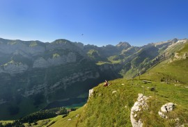
When you think of the great hikes in the Swiss Alps, your thoughts might instantly focus on the Jungfrau Region or in Valais-not bad for starters. But please don't overlook the splendid hiking found in the Alpstein range of eastern Switzerland in the canton of Appenzell—home to eastern Switzerland's highest peak, Santis.
Even though the Saxer Lücke is billed as a "geological theme hike" and the route is named after the most prominent geological fault in the Alpstein which forms a fissure or gap in the ridgeline (Lücke=gap), there is an amazing variety of trail interest, bobbing and weaving views, botanical surprises, wildlife, and other attractions to make this hike one of the greatest and most thoroughly enjoyable in the Alps.
The route begins in the village of Brülisau, just a 10 minutes bus ride from the town of Appenzell. Arriving at the tram station, you have the choice of hiking up to the Hoher Kasten mountaintop tram station and restaurant or taking the tram. For day hike, take the tram. If you want to make and spend the night at Stauberen or Bollenwees, take off on foot for the Hoher Kasten summit (1794m).
Once at the summit, you'll enjoy the panoramic views with the Rhine valley, Liechtenstein, and Austria's Tirol to the east, the green hills of Appenzell to the northwest, and the Alpstein range to the southwest. Then the fun begins as you follow the ridgeline to the south in the marked direction of the Saxer Lücke. The views continue along this descending ridge as it weaves from one side to the other.
Enjoy lunch at the Berggasthaus Staubern before continuing on to the Saxer Lücke, where the trail skirts to the west of the Hauser spire (1951m) and makes its steep descent at the gap. At the pass (1649m), the ridge trail connects with a mule track in the direction of Bollenwees to the west. As you descend the Saxer Lücke you lose your panoramic views, and you may even encounter some unpredictable weather-gusts of wind or pockets of fog-but you'll also be treated to views of the beautiful Bollenwees basin and the small lake below.
Bollenwees is a great overnight stop, as is the Samtissersee and Plattenbödeli just an hour down the trail-or you can continue on yet another hour to Brülisau to complete the mountain loop. In the evening, whether you decide to stay in a mountain gasthaus or return to Appenzell, don't miss the mealtime pleasure of a steaming plate of rösti smothered in aromatic Appenzeller cheese.
.jpg&w=270&h=183&zc=1)
.jpg&w=270&h=183&zc=1)