- Trips
- Tour Calendar
- About Our Tours
- Plan a Trip
- Book a Trip
- About Us
- Contact Us

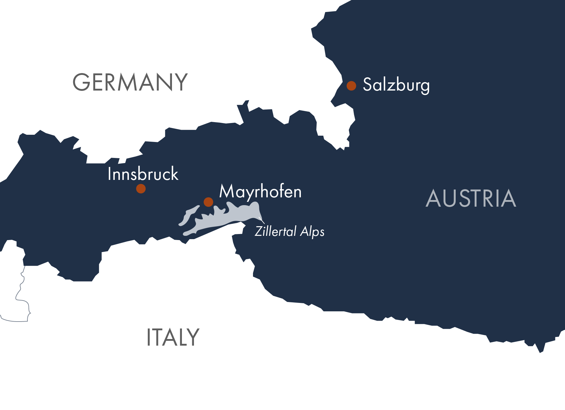
Mayrhofen is one of Austria’s most popular ski resorts and provides many wonderful hiking trails in the summer. This region is one of the most popular hiking areas in the Alps that is well connected by trains, buses and cable cars. Today, you will take the train to village of Mayrhofen (about 1 hour from Innsbruck). You should have time this afternoon to explore the town and visit the local ErlebnisSennerei Dairy. This is a traditional family-owned dairy where you can take a tour to see the cheese-making process. Guests are also invited into the dairy's own farmyard with its cows, goats, sheep and chickens. (D)
Take a bus to the nearby village of Finkenberg which is located at the entrance of the Tuxertal valley between the spurs of the Penken and Grünberg mountains. In Finkenberg, you will find the Glocke nature reserve where you can learn about the area’s plants and animals while walking through the Tuxbach Gorge. From Finkenberg, take the Finkenberger Almbahn cable car up to the Penken mountain. Spend the day walking along the vast network of hiking trails providing amazing views overlooking Mayrhofen. Come down on the Penkenbahn cable car to Mayrhofen to walk back to your hotel. (BD)
Distance: 4-7 miles | Ascent: 775 feet | Descent: 750-1025 feet | Time: 2-4 hours (May vary)
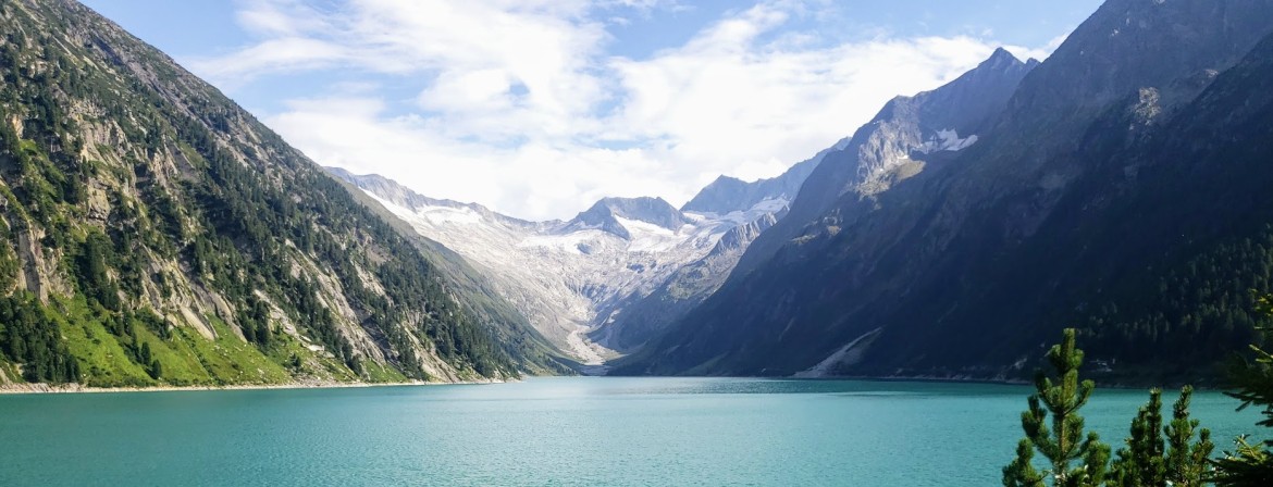
Take the bus to Guesthouse Breitlahner to start your hike up to the Legendary Berliner Hütte that is situated at an elevation of 2042 meters. This mountain hut was built in 1879 and is the oldest and most well-known Alpine hut in the Zillertal Alps that is protected as a building of historical significance. This unique mountain Hütte is surrounded by the peaks and glaciers of Zemmgrund and offers panoramic views of the Hornkees and Waxeggkees Glaciers. If you are up to more hiking, you can continue up to Schwarzee lake in the afternoon before returning to the Berliner Hütte for the evening. (B)
Distance: 5.5 miles | Ascent: 2550 feet | Time: 3 hours (May vary). Optional afternoon hike up to the Schwarzee lake for legendary views. Roundtrip Distance: 3.5 miles | Ascent: 1300 feet | Descent: 1300 feet |Time: 2.5 hours roundtrip (May vary)
Walk along the same hiking route from the Berliner Hütte back to the Breitlahner hut. Take the bus out to Schlegeis Reservoir and walk along the 725-meter long and 131-meter high Schlegeisspeicher Dam or explore the interior of the dam on a guided tour. Hike up to the Olpererhütte for breathtaking views of the Schlegeis Basin with its vibrant emerald green water surrounded by impressive mountains and glaciers of the Zillertal Alps. Return by bus to Mayrhofen. (D)
Stats for coming down from Berliner Hütte: Distance 5.5 miles | Descent: 2550 feet |Time: 2.5 hours. Stats for Olperer Hike: Roundtrip Distance: 4.6 miles | Ascent: 1875 feet | Descent: 1875 feet |Time: 3-3.5 hours roundtrip.(May vary)
From Mayrhofen, take the Ahorn cable car to the top where there are several hikes, playgrounds, lake Ahornsee and four viewing platforms on the Ahorn plateau. Options include hiking roundtrip to the Edelhütte that sits below the Ahornspitze mountain. Another great hike is to the Filzenkogel where you can take in the impressive scenery and record your name in the summit log. If you enjoy birds, you can watch the Birds of Prey show that takes place daily at 2:00 pm (except Tues). Return by cable car down to Mayrhofen. (BD)
Distance: 3.7 -5.5 miles | Ascent: 950-1915 feet | Descent: 950 -1915 feet |Time: 2.5 -4 hours roundtrip (May vary)
Take a bus to Hintertux today where you can take the cable car up to Sommerberg. Hike to the Tuxerjoch Haus and you can even continue hiking up to the. You can take the cable car back down or walk along the Weitental trail and visit the Schierer waterfall. If you want to take the cable car up to the top of the ice glacier you can ski, visit the Natur Eis Palast, go tubing in the Gletscherflohpark or walk along the Gletscherwanderung. Return by bus to Mayrhofen. (BD)
Stas for hike to Tuxerjoch Haus: Distance: 6.5 miles| Ascent: 1575 feet | Descent: 1425 feet |3-4 hours. Stats for Weitental Trail: Distance: 2.8 miles| Ascent: 225 feet | Descent: 1975 feet |2 hours. (May vary)
Take the Zillertalbahn train from Mayrhofen back to Jenbach to continue on your onward journey. (B)
Alpenwild Adventures are designed for people who are energetic, active and filled with a spirit of adventure. We rate this trip as moderate. You should be a strong and experienced hiker in good physical condition. You should be capable of walking 4 to 6 hours per day on good trails, ascending up to about 3,000 vertical feet per day, at an elevation up to 9,000 feet above sea level.
