Location: Jungfrau Region
Distance: 4-10 miles, depending on variation
Duration: 2-8 hours, depending on variation
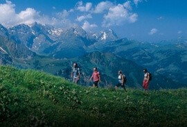
The Lauterbrunnen Valley is the world's most spectacular glacial valley and it's ringed by 72 waterfalls, including some of the highest in Europe. There's no better introductory hike to this valley than the loop that leads from the town of Lauterbrunnen up to Grütshchalp, then on to Mürren and Gimmelwald, before descending and returning to Lauterbrunnen. With three different cableways to make the ascent and descent, and a train and bus to cover most of the terrain in between, you could conceivably use mechanized means to cover the entire distance--but you'd miss so much.
Starting in Lauterbrunnen, most hikers take the tram that departs opposite the Lauterbrunnen train station and makes the quick ascent to Grütschalp. The a pied alternative is a well marked and lovely forest trail that takes about 90 minutes. So unless you are craving the workout and are ready to start your day with an ascent of 2275 vertical feet, take the tram. As you make the ascent, look down to the slope below and you'll see the base of the funicular which once served this route. The funicular was subject to landslides and was replaced by the current tram in 2006. You'll also notice that the tram--the primary means of transporting goods to car-free Mürren--is designed to carry freight in the cabin beneath.
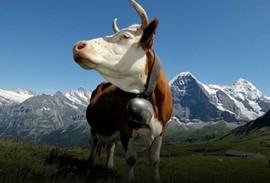
Once you've arrived at Grütschalp (elevation 4885 ft) you'll find a train waiting to take you on to Mürren. For skiers or those with luggage spending a few days in Mürren the train is a must. But if you're a hiker or even a casual walker you don't want to miss the stroll to Mürren along a gentle forest path, crossing a dozen streams, one of which is the Staubbach whose waters quickly plunge over a cliff and form Staubbach Falls, the signature waterfall of the Lauterbrunnen Valley. Along the way you pass the Winteregg dairy on the right where you'll find locally produced cheese, yogurt, caramels, and other snacks. As an alternative route to the wide graded roadway, there is also a quieter wanderwegwhich runs parallel to the graded road and up the hillside to the left. After about an hour of walking and an elevation gain of over 500 feet, you arrive in Mürren (elevation 5,397 feet). You'll find plenty of viewpoints along the way to Mürren, but one of the best and most popular is the small plaza and overlook on the south side of the train station. Here you'll find coin operated binoculars, but they could hardly capture or improve on the sweeping alpine panorama that's laid out before you, with the Jungfrau as the glorious centerpiece. There is also an unflattering bas relief memorial to Sir Arnold Lunn, who invented the first slalom skiing race on the slopes above Mürren in 1922. Prior to Lunn's race, slalom competitions were judged on style.
Continuing on through Mürren the road descends through a mix of modern apartments and centuries-old farm houses before descending to the lovely village of Gimmelwald (4,655 ft) on a perch facing the upper Lauterbrunnen Valley. From here you can take the steep forest descent or the tram down to Stechelberg, located at the top of the main Lauterbrunnen Valley. The tram takes you to a station on the valley floor about a half mile down the valley from the center of Stechelberg village. From the tram stop, it's just a 20 minute walk to Trümmelbach Falls on the east side of the valley and to your right. There is also PostBus service from the tram stop to entrance of Trümmelbach Falls.
Trümmelbach Falls is one of those "must see" natural wonders. It's a series of 10 pounding waterfalls that have cut through the rock to form immense underground channels and torrents. Fed by the glaciers of the Eiger, Mönch, and Jungfrau, 20,000 liters of water per second pound their way through the chasm to the valley below. This underground spectacle is made ingeniously and perfectly accessible by a tunnel funicular and a series of illuminated tunnels, galleries, and balconies. It's an amazing delight and a tribute to Swiss engineering, which always seems to make natural wonders so accessible. From Trümmelbach Falls, return to Lauterbrunnen by bus or follow the riverside trail past meadows, small farms, and waterfalls on every side. It's about 45 minutes on foot from Trümmelbach Falls back to Lauterbrunnen. This walk can easily be done in reverse, but I seem to prefer the direction described above since it has you facing the finest views on the stretch from Grütschalp to Mürren. Although this walk has always been a regular summer event for me, I had the pleasure in 2011 of tackling this route in winter with lightly falling snow and on a layer of compacted snow and ice. Footwear traction or flexible crampons were essential, the mountain views were non-existent, and Trümmelbach Falls was closed for the season, but the route was perfectly enjoyable. In winter or summer, there's no sense in rushing this walk. This hike is featured on Alpenwild's Best of the Swiss Alps and Exploring the Jungfrau trips, or contact us for a custom or self-guided itinerary.