


What a great trip. It exceeded our wildest expectations. The attention to details was fabulous. We would take the trip again in a heart beat. - C.H., Ohio
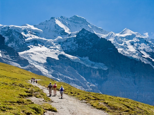
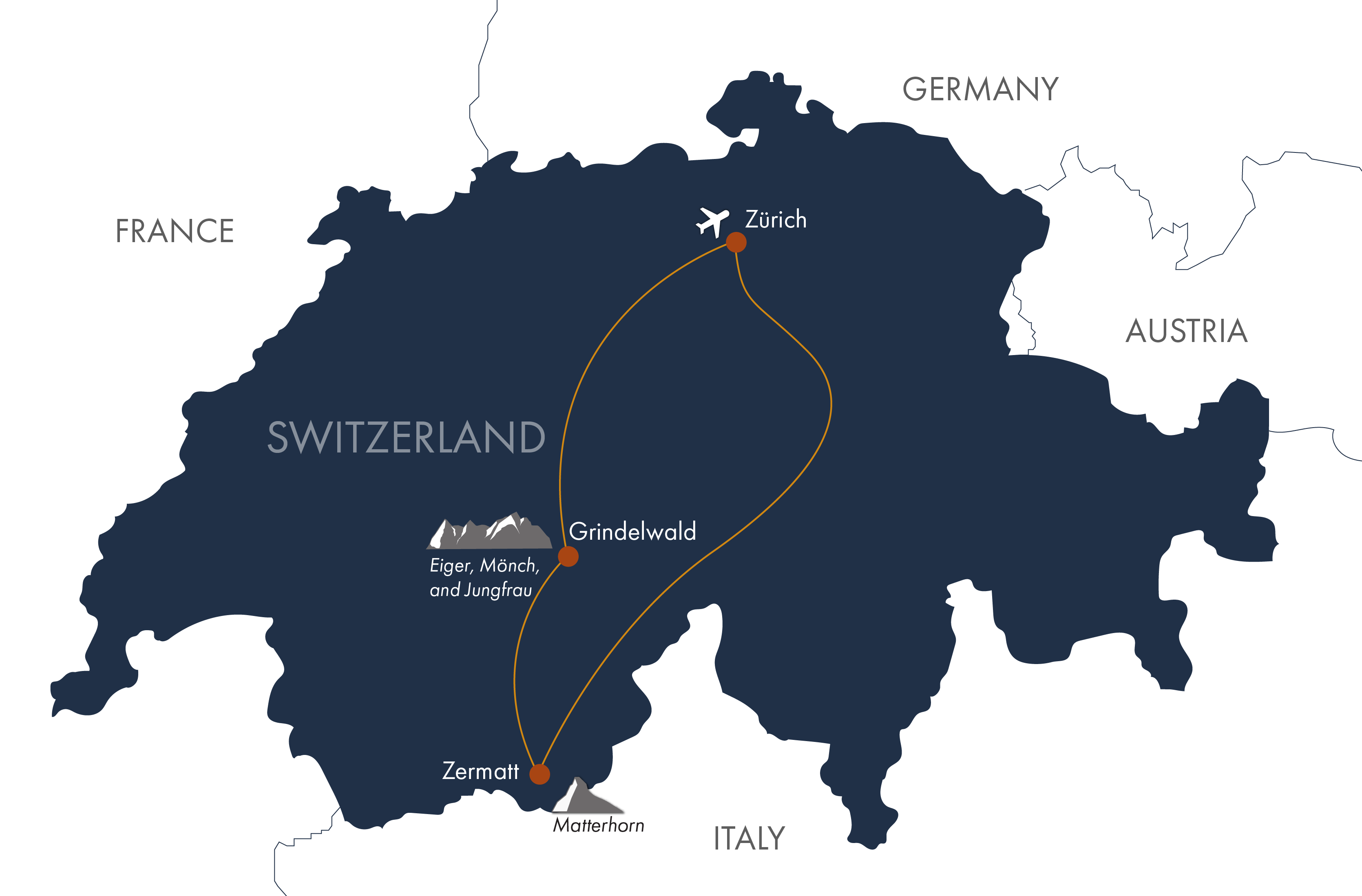
Travel by trains to the charming alpine village of Grindelwald, nestled in Switzerland’s Bernese Oberland within the UNESCO World Heritage-listed Jungfrau region, home to the Alps’ densest concentration of glaciers. In the afternoon, take a cable car to Männlichen and traverse the dramatic “Royal Walk” to Kleine Scheidegg, with sweeping views of the Eiger, Mönch, and Jungfrau peaks, before returning to Grindelwald by train.
Ascent: 50-300 feet | Descent: 575-825 feet | Distance: 2.8-3.6 miles
Lauterbrunnen, the “Valley of 72 Waterfalls,” is a breathtaking alpine paradise of soaring cliffs, lush meadows, and charming chalets. Explore the dramatic 10-tiered Trümmelbach Falls, carved by glacier waters from the Eiger. Then ascend by tram to the Schilthorn summit, where the Bond Museum, panoramic Swiss vistas, and a mountaintop restaurant await. Descend to the car-free village of Mürren before returning to Grindelwald, soaking in the alpine beauty along the way. (B)
Distance: 4-10 miles | Ascent: 200-2900 feet | Descent: 500 feet
Ride the Eiger Express V-Bahn cable car up to Eigergletscher, then embark on an exhilarating cogwheel train climb through a tunnel inside the Eiger to reach the Jungfraujoch—the highest railway station in Europe—overlooking the Alps’ longest glacier. From Eigergletscher, choose your adventure: a scenic Eiger Walk down to Kleine Scheidegg, or a longer trek along the Eiger Trail, bringing you face-to-face with the legendary Nordwand, the iconic North Face of the Eiger. Return to Grindelwald by train. (B)
Distance: 4-6 miles | Ascent: 75-775 feet | Descent: 2400-3000 feet
From Grindelwald, ride the gondola up to “First” and hike to the sparkling alpine lake of Bachalpsee (7,431 ft), framed by the snowcapped peaks and glaciers of the Jungfrau region. Continue along the trail to Faulhorn, where sweeping vistas stretch into Germany. Return to First and descend to Grindelwald—choose the gondola for a relaxed ride, or add excitement with the zipline, mountain cart, scooter, or a scenic walk. (B)
Distance: 3.7-7.4 miles | Ascent: 500-2900 feet | Descent: 500-1760 feet
Take a train to the historic alpine village of Zermatt (3.5 hrs). In the afternoon, venture into the Gornerschlucht, a deep, dramatic canyon where roaring waterfalls cascade past a thrilling network of stairways and footbridges, offering an unforgettable high-alpine adventure. (B)
Distance: 3.2 miles | Ascent: 450-550 feet | Descent: 500-1200 feet
Take the classic cogwheel railway from Zermatt to the Gornergrat (10,285 ft), where sweeping vistas of the iconic Matterhorn await. Explore the rugged trails around Riffelberg and Riffelsee, or follow a scenic descent back to Zermatt, immersing yourself in the high-alpine beauty of this legendary landscape. (B)
Distance: 2 -6 miles | Ascent: 50-200 feet | Descent: 900-3946 feet
Take the funicular up to Sunnegga, where sweeping views of the Mattertal Valley stretch out before you. From here, embark on the exhilarating Five Lakes circular hike, wandering past sparkling alpine lakes framed by rugged peaks and dramatic high-alpine landscapes. (B)
Distance: 6 miles | Ascent: 1425 feet | Descent: 1475 feet
Today, explore Zermatt’s Glacier Trail, a thrilling high-alpine hike with sweeping views of glaciers, towering peaks, and dramatic Swiss landscapes. Along the way, witness the power of nature as glaciers reveal the geological forces that have shaped these mountains. In the afternoon, enjoy free time to shop or visit the Matterhorn Museum. (B)
Distance: 4.1 miles | Ascent: 571 feet | Descent: 1690 feet (may vary)
After breakfast, you can depart for onward destinations. (B) Note: it is just over 3.5 hours by trains to Zürich airport, and the first train departs Zermatt at 5:37 am, so plan departure flights accordingly. We can recommend hotels in Zürich if needed.
Daily distance measurements may vary depending on the device you use to track them. If a range is provided for the statistics, it is possible to hike closer to the lower end, and we’ll include options in your detailed daily directions. Use the listed figures as estimates and reference points while preparing and training for this tour.
We rate this trip as moderate but also adaptable to those who want easier or longer hikes on some days. Please note that the stats listed on the itinerary can vary, depending on the guide and desires of our hikers. You should be capable of walking 4 to 6 hours per day on well-groomed and graded trails at an elevation up to 9,000 feet above sea level. On one day a mountain railway takes you to an elevation of 11,400 feet to the Jungfraujoch.

