

“The Dolomites were incredible and the food was fantastic.” - Alta Via 1 guest
You will meet the group and your taxi service (Taxi Vico) outside the Hilton Garden Inn Venice Mestre San Giuliano at 9:00 am. Your group will take this shuttle to Sexton, a village ourside of San Candido in northern tip of the Italian Dolomites. Here, you will meet your guides at a local restaurant for lunch before going on a leisurely hike. We will then transfer to our hotel in San Candido to relax before meeting the group again for a short orientation followed by a charming dinner of local cuisine. (LD)
Ascent: 700 feet | Descent: 700 feet | Distance: 2.5 miles (may vary)
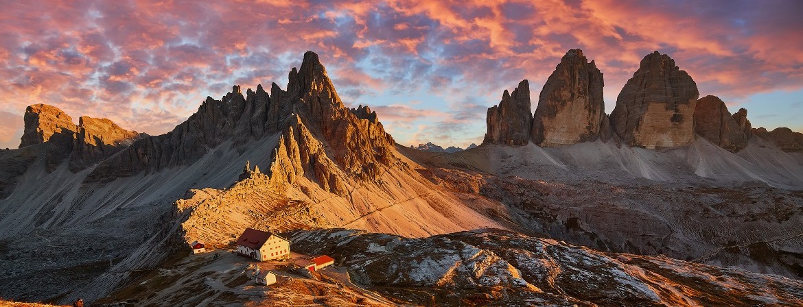
We start our trek with a hike to the Tre Cime di Lavaredo, an icon of the Dolomites. Taking a lesser-known route, we capture the spectacular views of these epic rock monoliths. We descend into the Val Fiscalina and return to our welcoming hotel in San Candido. (BLD)
Ascent: 3,400 feet | Descent: 3,300 feet | Distance: 10 miles (may vary)
We begin the day surrounded by the spectacular beauty of Lago di Braies with the iconic views of Sass dla Porta towering above the lake. We hike up to Forcella Sora Forno and have lunch at one of the many rifugi located atop this alpine plateau, before descending into Val di Rudo to arrive at Rifugio Pederü. This rifugio dates back to World War I, when the village of Pederü was a camp for the Kaiserjäger - the Emperor's Hunters. (BLD)
Ascent: 3,500 feet | Descent: 3,300 feet | Distance: 9 miles (may vary)
We ascend to the high alpine pastures of Val di Fanes. The Fanes Valley— known as the Parliament of Marmots—is set within a glacially sculpted amphitheater dotted with lakes and cut with pure mountain spring water. It’s a great place to relax and soak in the natural beauty of the alpine setting, or take advantage of some of the afternoon hikes in the area. We spend the night in a favorite mountain rifugio in the Fanes Valley. (BLD)
Please note that there are no luggage transfer to this rifugio and you will need to carry whatever you need for the night and following day in your backpack.
Ascent: 2,000–3,200 feet | Descent: 300–1,200 feet | Distance: 4 or 8 miles (may vary)
Departing Val di Fanes, we’ll ascend the Forcella Lagazuoi and follow an exhilarating trail down to the breathtaking Lago di Lagazuoi. After a hearty lunch at Rifugio Scotoni, renowned for its grilled specialties, we’ll continue our descent into Alta Badia, where we’ll unwind and enjoy some well-deserved relaxation at our hotel in San Cassiano. (BLD)
Ascent: 2,000 feet | Descent: 3,200 feet | Distance: 9 miles (may vary)
We strongly recommend taking advantage of today as a well-deserved recovery day and spending time enjoying the incredible spa facilities at the hotel. After several days of hiking, this is the perfect opportunity to relax tired muscles, soak in the alpine atmosphere, and recharge before the adventures ahead.
For those interested in hiking today, we'll start directly from our hotel in San Cassiano, following a trail along the Santa Croce beneath the towering cliffs of Sasso della Croce. Our journey will lead us to a stunning mountain church. From here, guests can choose to return to the hotel and indulge in its wonderful spa or continue to a charming mountain hut for lunch.
This evening, guests can eat dinner at the hotel again (included) or have the option to enjoy dinner on their own in town. (BLD)
Ascent: 1,800–2,100 feet | Descent: 100–2,700 feet | Distance: 4 or 9 miles (may vary)
The region around the Passo di Valparola and Lagazuoi formed one of the front lines for the Austro-Hungarian forces in WWI—a line which they fiercely maintained throughout the war. Today we hike through the Austrian trenches to the summit of Sasso di Stria, a natural fortress which was crisscrossed with tunnels, bunkers, and trenches, and which now stands as an open-air museum of the conflict. On to Passo Falzarego we take the cable car to Rifugio Lagazuoi for short hikes near the summit and a panoramic lunch. We traverse under the majestic south face of Tofana de Rozes and make our way down to Cortina. (BLD)
Ascent: 1,200–1,500 feet | Descent: 1,500–4,000 feet | Distance: 3 or 8 miles (may vary)
Today we will find our way around the maze of towers that make up Cinque Torri, exploring the the Italian WWI front line. We will visit the oldest rifugio in the Dolomites - Rifugio Nuvolau - and taste arguably some of the best Casunziei (fresh beetroot-filled pasta) in the Dolomites, before returning to Cortina. Cortina d’Ampezzo, site of the 1956 Winter Olympic Games and soon the 2026 Winter Games, is a wonderful town to spend the afternoon exploring. The evening will be free for guests to enjoy dinner on their own. (BL)
Ascent: 2,300 feet | Descent: 1,700–2,900 feet | Distance: 5 or 7.5 miles (may vary)
We bid farewell to Lagazuoi, Tofana di Rozes and Cinque Torri, and look forward to Monte Pelmo and Civetta Massif. Hiking under the rock spines of Croda da Lago, we cross high alpine meadows to Forcella Ambrizolla. Passing a 7500-year-old Late Mesolithic site we descend to Rifugio Citta di Fiume for lunch under Monte Pelmo, known locally as "al caregon de'l Padreterno", or "God's Throne". We drop further into Val di Zoldo for the evening. (BLD)
Ascent: 1,900 feet | Descent: 3,100 feet | Distance: 9 miles (may vary)
We enter a more wild and less traveled portion of the Alta Via 1, but there are still welcoming rifugi along the route where we can stop for refreshment. Coffee and strudel at Rifugio Coldai whilst admiring Monte Pelmo, lunch on the terrasse of Rifugio Tissi, gazing at the imposing vertical walls of Monte Civetta; and dinner at the Rifugio Vazzoler, contemplating the glowing ember of Torre Trieste montain in the setting sun. (BLD)
Please note that there are no luggage transfer to this rifugio and you will need to carry whatever you need for the night and following day in your backpack.
Ascent: 2,800–3,800 feet | Descent: 3,100 feet | Distance: 7.5 or 9.5 miles (may vary)
Departing the heart of the Civetta Massif we hike to Rifugio Carestiato for lunch then make our way down to Passo Duran and on to the conclusion of our Alta Via 1 adventure. A private shuttle will meet us and take us to our hilltop castle hotel overlooking the rugged hillside vineyards of the Prosecco region, to celebrate our final evening together. (BLD)
Ascent: 2,200 feet | Descent: 2,500 feet | Distance: 7.5 miles (may vary)
Following breakfast at our castle hotel, we travel through vineyards for a Prosecco tasting and light lunch at the estate of a leading producer. We will then transfer back to Venice for our final evening at an included accommodation near the Marco Polo Airport. (BL)
Ascent: 40 feet | Descent: 300 feet | Distance: 0.9 miles (may vary)
Depart Venice on return flights or onward travel. Shuttle from Venice hotel to Marco Polo airport is provided. (B)
Alpenwild trips are designed for people who are energetic, active, and filled with a spirit of adventure. We rate this trip as strenuous. You should be capable of walking 6 - 8 hours per day on well-groomed and rocky trails at an elevation up to 7,000 feet above sea level.

.png&w=370&h=296&zc=3)
.png)