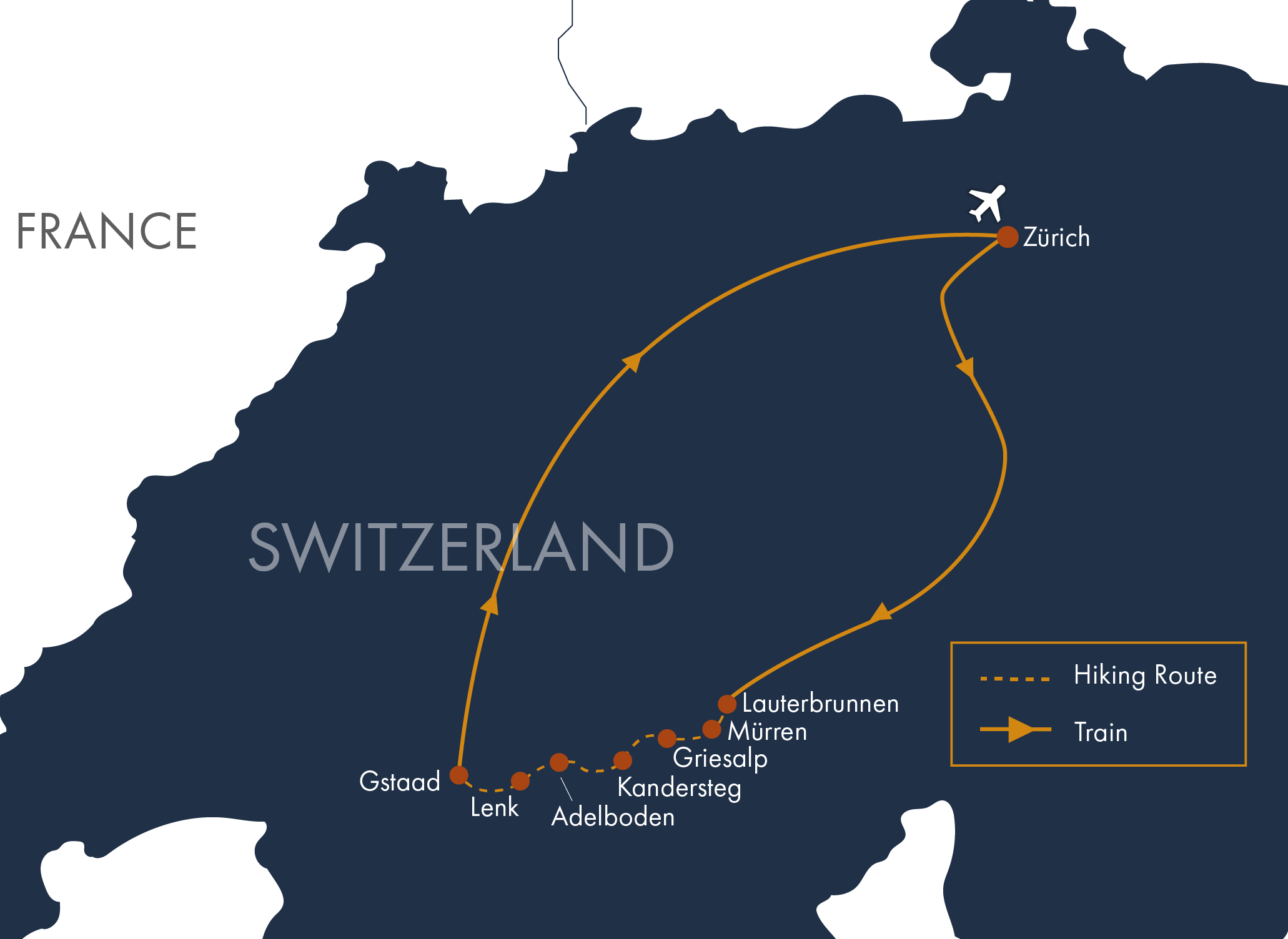

Travel by Swiss rail to the beautiful village of Lauterbrunnen. In the afternoon, take the train to Wengen and a cable car to Männlichen, where you can enjoy the scenic “Royal Walk” to Kleine Scheidegg. Return to Lauterbrunnen by train.
Distance: 2.8–3.6 miles (4.5–5.8 km) | Ascent: 50–300 feet (15–91 m) | Descent: 575–825 feet (175–251 m)
Today’s hike takes you through the breathtaking Lauterbrunnen Valley, a pastoral landscape framed by towering cliffs and adorned with 72 waterfalls cascading to the valley floor. This enchanting scenery is said to have inspired Tolkien’s The Lord of the Rings, and it’s easy to understand why. Along the way, explore the dramatic, ten-tiered underground Trümmelbach Falls before continuing uphill to the traditional farming village of Gimmelwald and on to Mürren, where sweeping views of the Eiger, Mönch, and Jungfrau await. (B)
Distance: 5–7.5 miles (8–12.1 km) | Ascent: 400–2,800 feet (122–853 m; variable) | Descent: 75–300 feet (23–91 m)
From Mürren, ascend the Sefinental Valley past Rotstockhütte to cross the high, rocky terrain of the Sefinenfurgge. Watch for chamois grazing on the slopes below the pass. A steep descent along a stairway of more than 300 steps bypasses the challenging scree slopes and leads into the secluded and beautiful Kiental Valley. Your destination is Griesalp, a traditional farming hamlet where a charming hotel complex of five buildings offers a peaceful alpine retreat. (BD)
Distance: 10 miles (16.1 km) | Ascent: 3,300 feet (1,006 m) | Descent: 3,900 feet (1,189 m)
Enjoy a welcome rest day in the beautiful alpine hamlet of Griesalp, with plenty of opportunities to explore at your own pace. Optional hikes offer a chance to discover more of this spectacular mountain landscape, including Wildwasser Gorge, where a dozen waterfalls, chutes, and cascades tumble through the chasm below the village. After a day outdoors, unwind in the afternoon with a relaxing visit to the sauna and steam room. (BD)
Hiking: Optional, with variable distance, ascent, and descent depending on your chosen route.
From Griesalp, ascend the spectacular Hohtürli Pass, the most challenging pass of the journey. A sturdy stairway of approximately 500 steps helps you avoid the scree slopes, though the climb remains strenuous. From the glacial terrain on the northern flank of the Blüemlisalp massif, enjoy captivating views of the Blüemlisalp Glacier as you descend to the picturesque Oeschinensee. From there, choose between a cable car ride or a hiking trail down to Kandersteg. (BD)
Distance: 7.5–9 miles (12.1–14.5 km) | Ascent: 3,300–4,600 feet (1,006–1,402 m) | Descent: Approximately 4,000 feet (1,219 m) - these stats assume you will ride cable car down to Kandersteg from Oeschinensee
Surrounded by towering cliffs, lush alpine meadows, and glaciated peaks, Kandersteg offers a beautiful setting for a more relaxed hiking day. You can explore the UNESCO-recognized Gasterntal, where glacier-fed waterfalls flow into the Kander River. Follow a scenic trail down through the Chluse Gorge and return to Kandersteg, with the option to take a bus for part of the way. (B)
Recommended Route — Distance: 7 miles (11.3 km; variable if taking the bus) | Ascent: 175 feet (53 m) | Descent: 1,400 feet (427 m)
From Kandersteg, take a cable car to Allmenalp and follow a remote trail beneath Gällihorn before ascending the classic Bundergrat ridge. A short 20-minute detour takes you to the summit of Bunderspitz, where sweeping views extend across much of the Bernese Alps and down to Lake Thun. Descend into the expansive valley below to reach Adelboden, a popular World Cup ski resort town. (BD)
Distance: 8.5 miles (13.7 km) | Ascent: 2,500 feet (762 m) | Descent: 3,900 feet (1,189 m)
From the heart of Adelboden, take a cable car to Sillerenbühl, gaining quick access to high alpine pastures and a scenic trail toward Hahnenmoospass. Although it is the lowest pass on the journey, Hahnenmoospass offers impressive panoramic views in every direction. We recommend descending via Pommernpass to the spectacular Simmenfälle waterfalls, then taking a bus into Lenk. (B)
Distance: 7–7.5 miles (11.3–12.1 km) | Ascent: 625–825 feet (191–251 m) | Descent: 3,300–3,500 feet (1,006–1,067 m)
Take a cable car to Betelberg Leiterli, where you’ll follow much of the Via Alpina trail toward Trüttlisbergpass. Descend along a scenic route to the charming village of Lauenen before continuing to Gstaad for a celebratory finish in one of the Alps’ most fashionable mountain towns, where Swiss tradition meets upscale alpine charm. (BD)
Distance: 7–11 miles (11.3–17.7 km) | Ascent: 500–1,575 feet (152–480 m) | Descent: 2,850–3,475 feet (869–1,059 m)
Gstaad resident Julie Andrews once described this alpine haven as “the last paradise in a crazy world.” Enjoy a leisurely day soaking in the village’s refined alpine charm or choose from a variety of outdoor adventures in the surrounding mountains. Take a scenic local hike or venture to Glacier 3000 for breathtaking panoramic views, a thrilling crossing of the Peak Walk suspension bridge, and the rare opportunity to walk on a glacier high in the Alps. (B)
Hiking: Optional, with variable distance, ascent, and descent depending on your chosen activity.
Onward Departure (B). Note: it is a 3-3.5-hour train ride to Zürich airport and the first train departs Gstaad at 5:03 am (weekdays) and 6:25 am (weekends), so plan departure flights accordingly. We can recommend hotels in Zürich if needed.
Daily distance measurements may vary depending on the device you use to track them. If a range is provided for the statistics, it is possible to hike closer to the lower end, and we’ll include options in your detailed daily directions. Use the listed figures as estimates and reference points while preparing and training for this tour.
We rate this trip as strenuous. You should be an experienced hiker in good physical condition. You should be capable of walking 7-8 hours per day on good trails with some steep ascents and descents, averaging 2500-4500 vertical feet per day at an elevation up to 8500 feet above sea level. Sure-footedness is important and vertigo may impact your ability to do this tour. We cross two of the most spectacular and challenging hiking passes in the Swiss Alps—the Sefinenfurgge and the Hohtürli. On these passes, there are long staircases, scree slopes, some exposed drop-offs protected by cables or handholds, and short ladder assists of about 2 meters. You’ll want to be a sure-footed, experienced hiker with a head for heights. Please note that there are three days during this tour with elevation gains between 3700 and 4400 vertical feet.
Assume 2.5 miles/hour on the flat.
Assume 1200 feet of up per hour.
Assume 2000 feet of down per hour.