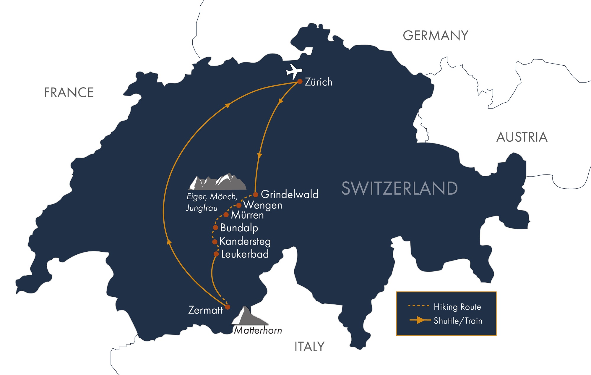

Travel by train from Zürich to Grindelwald (approximately 3.5 hours), a beautiful alpine village in the heart of the Jungfrau Region, beneath the towering North Face of the Eiger. In the afternoon, enjoy an optional hike by taking the gondola to First and following a scenic trail to Bachalpsee, a tranquil alpine lake that reflects the surrounding snowcapped peaks and glaciers. (D)
Distance: 3.7 miles (6 km) | Ascent: 500 feet (152 m) | Descent: 500 feet (152 m)
From Grindelwald, take the train to Alpiglen to begin your ascent along the spectacular Eiger Trail. This panoramic route runs beneath the legendary North Face of the Eiger, offering dramatic views of the climbing routes that challenged mountaineers during the pioneering attempts of the 1930s. You may also choose an optional rail excursion through the Eiger tunnel to Jungfraujoch, Europe’s highest railway station, for sweeping views of the Great Aletsch Glacier, the longest glacier in the Alps. Continue hiking from Eigergletscher to Kleine Scheidegg, then follow the scenic Royal Walk to Männlichen. From there, descend by cable car to the mountain village of Wengen. (B)
Distance: 4–8 miles (6.4–12.9 km) | Ascent: 2,500–3,000 feet (762–914 m) | Descent: 200–1,075 feet (61–328 m)
Today, cross the scenic Lauterbrunnen Valley from your perch in Wengen to the car-free mountain resort of Mürren on the opposite side. Along the way, enjoy an optional riverside walk through the valley, where you can admire some of its famous 72 waterfalls cascading from towering cliffs. Be sure to visit Trümmelbach Falls, a spectacular series of ten underground waterfalls carrying glacial meltwater from the Eiger, Mönch, and Jungfrau region. Arrive in Mürren, where your hotel offers breathtaking views of the Eiger, Mönch, and Jungfrau peaks. (B)
Distance: 5–11 miles (8–17.7 km) | Ascent: 400–2,765 feet (122–843 m; variable) | Descent: 75–1,200 feet (23–366 m)
From Mürren, ascend through the Sefinental Valley past Rotstockhütte toward the rugged heights of Sefinenfurgge Pass. Watch for ibex grazing on the slopes below the pass. A steep descent via a staircase of more than 300 steps avoids loose scree and leads into the secluded beauty of the Kiental Valley. Your day concludes in Griesalp, a tranquil farming hamlet where a charming hotel complex offers a welcoming retreat in this remote alpine setting. (BD)
Distance: 11 miles (17.7 km) | Ascent: 3,300 feet (1,006 m) | Descent: 4,000 feet (1,219 m)
Griesalp is a peaceful and scenic destination, perfect for those looking to unwind and immerse themselves in the natural beauty and charm of the Swiss Alps. Whether you're into hiking or relaxation, there's something for everyone to enjoy in this enchanting alpine hamlet. This area offers numerous day hikes, including a walk through the Wildwasser chasm below Griesalp, where you'll be surrounded by a dozen waterfalls, chutes, and cascades along the trail. In your free time, plan on enjoying the sauna or reserve an outdoor hot pot while taking in the outstanding mountain views. (BD)
Ascent, descent, and distance are variable and optional today
The most challenging pass on your journey will be the magnificent Hohtürli pass between Griesalp and Kandersteg. Near the top, a well-built staircase with over 450 steps helps you navigate above the scree and helps with the challenging ascent. As you traverse the glacial terrain on the northern flank of the Blüemlisalp massif, you’ll be mesmerized by the stunning Blüemlisalp Glacier and the breathtaking Oeschinensee mountain lake with vibrant turquoise waters. You can choose to stay up on the high trail or hike down to walk along the water's edge. Make your way to the cable car station for the ride down to Kandersteg. (BD)
Distance: 7.5–9 miles (12.1–14.5 km) | Ascent: 3,300–4,600 feet (1,006–1,402 m) | Descent: About 4,000 feet (1,219 m)
From Kandersteg, you take the Sunnbühl cable car that rises above the seemingly insurmountable mountain faces surrounding this town. From the top, you will follow a gentle path historically used by traders, smugglers, and travelers alike. With the shallow waters of the Daubensee glimmering to your right, you’ll take a short, well-maintained trail leading to the saddle of the Gemmi Pass. This pass once served as the main route connecting Bern to the Rhone Valley and was favored by literary giants such as Mark Twain, Goethe, Jules Verne, and Sir Arthur Conan Doyle. Your descent will take you down the imposing cliffs of the Daubenwand along a steep yet expertly constructed 17th-century mule track built by experienced Tyroleans, skilled in the use of explosives. This trail will lead you into the spa resort of Leukerbad for the evening. If you prefer a more leisurely descent, you have the option to take the cable car down to Leukerbad instead. (BD)
Distance: 5–8 miles (8–12.9 km) | Ascent: 1,600 feet (488 m) | Descent: 175–3,200 feet (53–975 m)
From Leukerbad, take the train across the Rhône Valley to Randa, where you begin your hike. Ascend through larch forest to the spectacular Charles Kuonen Suspension Bridge, the longest pedestrian suspension bridge in the Alps. After crossing the bridge, follow the trail back down to Randa. From there, board the train to Zermatt, enjoying views of the Weisshorn along the way. Upon arrival, take in iconic views of the Matterhorn. (B)
Distance: 5.5 miles (8.9 km) | Ascent: About 2,500 feet (762 m) | Descent: 2,500 feet (762 m)
Enjoy a full day in Zermatt with a scenic cogwheel railway ride to Gornergrat. At the summit, take in spectacular views of the surrounding 4,000-meter peaks, including the iconic Matterhorn, first successfully climbed in 1865. On the way down, stop at Riffelsee for the chance to see the Matterhorn reflected in the lake, and enjoy hiking between railway stations. (B)
Distance: 2–6 miles (3.2–9.7 km; may vary) | Ascent: 50–200 feet (15–61 m) | Descent: 900–3,946 feet (274–1,203 m)
Onward Departure (B). Note: it is 3-hours by trains to Zürich airport and the first train departs Zermatt at 5:37am, so plan departure flights accordingly. We can recommend hotels in Zürich if needed.
Daily distance measurements may vary depending on the device you use to track them. If a range is provided for the statistics, it is possible to hike closer to the lower end, and we’ll include options in your detailed daily directions. Use the listed figures as estimates and reference points while preparing and training for this tour.
We rate this trip as strenuous. You should be an experienced hiker in good physical condition. You should be capable of walking 5 to 7 hours per day on good trails with some steep ascents and descents (averaging 2,000 to 3,300 vertical feet per day) at an elevation up to 10,000 feet above sea level. You will cross two of the most spectacular and challenging hiking passes in the Swiss Alps—the Sefinenfurgge and the Hohtürli. On these passes, there are long staircases, scree slopes, some exposed drop-offs protected by cables or handholds, and short ladder assists of about 2 meters. You’ll want to be a sure-footed, experienced hiker with a head for heights . Please note that there are two days during this tour with elevation gains between 3300 and 4600 vertical feet.
Assume 2.5 miles/hour on the flat.
Assume 1200 feet of up per hour.
Assume 2000 feet of down per hour.