"Our guides, Charlie and Jena were great. The scenery, hotels, and meals were terrific!" - Tyrolean Traverse Guest
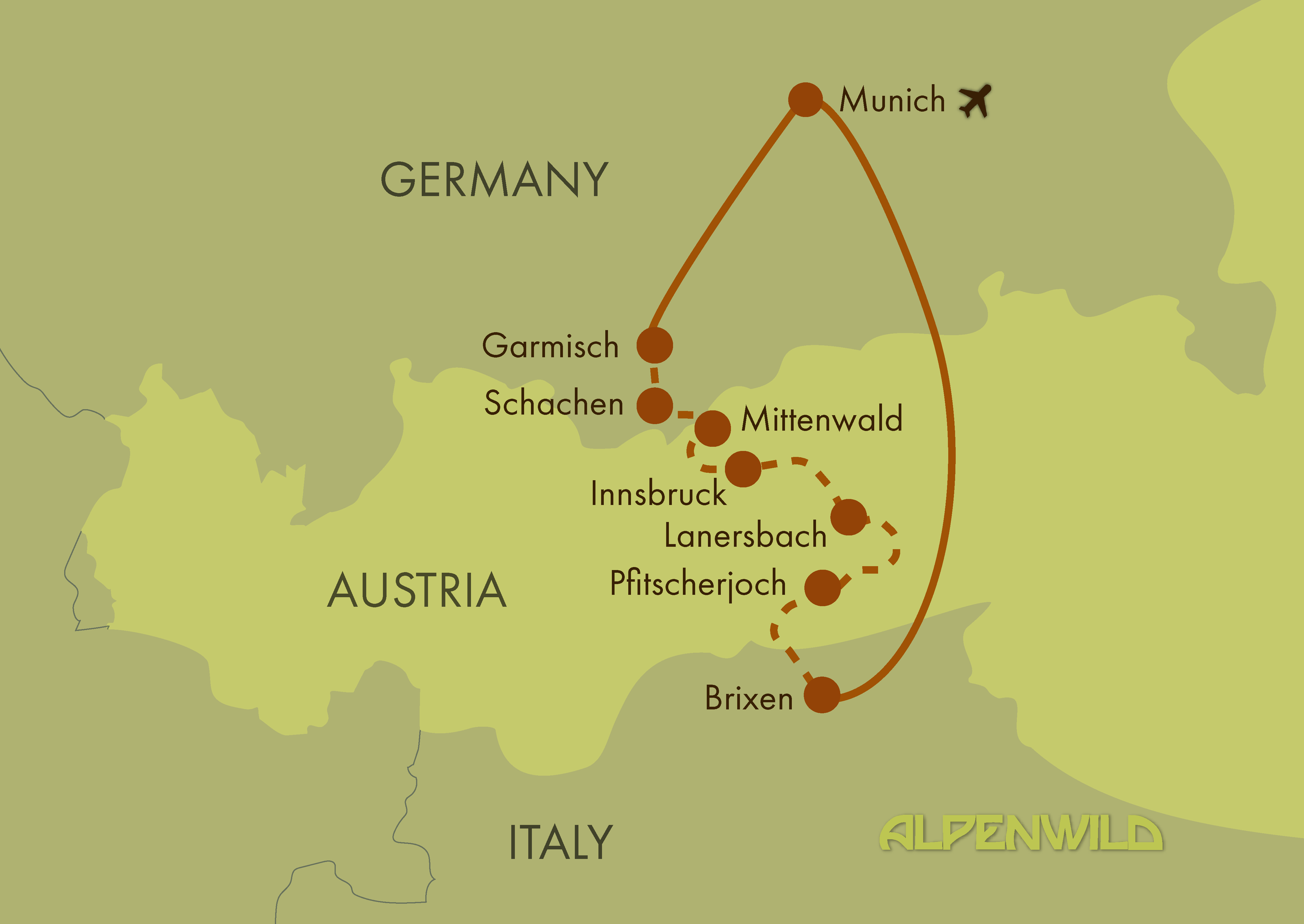
You’ll use your included train ticket to travel from Munich Airport to Garmisch-Partenkirchen. The group will meet at 1:00 pm in the hotel lobby for a briefing, followed by an afternoon gondola ride and hike offering breathtaking panoramic views of the Wetterstein Mountains and Germany’s highest peak, the Zugspitze. In the evening, the group will come together for a welcome dinner. (D)
Distance: 3 miles | Ascent: 1000 feet | Descent: 300 feet (may vary depending on the activity chosen by guides)
We will take an early taxi to the trailhead and wind along rushing mountain streams and past towering rock walls as we make our way through tunnels, bridges, and walkways carved into the gorge. Emerging from the gorge and after an early hut lunch, the route continues upward along an exciting trail hugging the cliff face. Panoramic views of the Wetterstein mountains await us at our high point. We save our knees for another day and finish the hike with a scenic gondola ride back down to Garmisch. (BLD)
Distance: about 7.5 miles | Ascent: 4200 feet ascent | Descent: 1300 feet (may vary)
After ascending by gondola to Germany's highest peak, we hike through a dramatic post-glacial landscape before crossing seamlessly into Austria. From the border, a spectacular alpine balcony trail traverses the mountainside above the Gaistal Valley, where we descend into one of Tyrol's most picturesque alpine meadows. (BLD)
Distance: 10.5 miles | Ascent: 1200 feet | Descent: 5600feet (may vary)
The idyllic alpine meadows of the Gaistal Valley invite us to slow down and savor one of Tyrol's most beautiful landscapes. Depending on the weather and the group's energy, you'll have a choice of several rewarding hikes to explore this peaceful valley. Or, if you'd rather enjoy a well-earned recovery after two spectacular hiking days, relax in the nearby wellness center and sauna world. This evening is yours to explore the village and enjoy dinner at your leisure. (BL)
Distance: 9 miles | Ascent: 3100 feet | Descent: 2700 feet (may vary)
We start today with the beauty of the Gleirschklamm, following a scenic valley path framed by steep rock walls and crystal-clear mountain streams. This gorge trail soon opens into a broad alpine basin, where rugged limestone peaks rise dramatically above traditional mountain pastures and quiet high-meadow landscapes. After coffee and cake at an alpine farm, the climb becomes more demanding as we make our way toward the Nordkette ridgeline. The ascent rewards us at every turn with expanding views over the Karwendel mountains, culminating at the Hafelekarspitze — one of Innsbruck’s most iconic viewpoints. At the summit, stand above the city with a panoramic sweep of jagged Karwendel peaks to the north, the Inn Valley unfolding far below and Italian South Tyrol beyond Brenner Pass. (BLD)
Distance: 5 or 9.5 miles | Ascent: 3600 0r 4400 feet | Descent: 200 or 400 feet (may vary)
Innsbruck blends imperial history with modern mountain living and makes for a great rest day location in the middle of this trip. Once a key seat of power in the Habsburg Empire, the city still carries the grand legacy of Imperial palaces, court gardens, and regal architecture that shaped Central Europe. Famous for its charming old town, colorful medieval streets and the Golden Roof, Innsbruck offers a unique mixture of culture, outdoor adventure and Tyrolean hospitality. For those that want to hike, we will f course offer a shorter hike on a nearby mountain South East of Innsbruck, with panoramic views across this wide glacial valley. Guests will be able to enjoy dinner on their own tonight. (BL)
Distance: 7 miles | Ascent: 2100 feet | Descent: 2300 feet (may vary)
A quick taxi ride takes us into our next mountain range - the Tux Alps. This is a less visited area of the Alps and has a wilder and more remote feeling. Our trail climbs steadily to the Torjoch, with a chance to stop in an alpine hut halfway for a strudel and Kapuziner (espresso with whipped cream). After a lakeside picnic lunch, the route continues along dramatic ridges toward the Grüblspitze, where sweeping vistas reward our effort and reveal the vast Tuxertal valley below. (BLD)
Distance: 8.2 miles | Ascent: 3400 feet | Descent: 2600 feet (may vary)
Today we join another section of the Munich - Venice long distance hiking route, with impressive close up views of the Hintertux glacier. We ascend alongside glacial run off streams to the mid station of Gefrorene Wand gondola. From here, people have the choice to leave the itinerary and take the cable car the rest of the way to the summit at 10500ft, or return to our accommodation to spend the afternoon relaxing in the welness area. The afternoon portion of the hike takes us through a remote valley to a beautiful waterfall. (BLD)
Distance: 2.5 or 9 miles | Ascent: 2000 or 3500 feet | Descent: 100 or 3500 feet (may vary)
Today's hike crosses from Austrian North Tyrol into Italian South Tyrol via the Pfitscherjoch Pass, following an ancient route that became an international border after the 1919 Treaty of Saint-Germain. Once a Stone Age hunting camp and later the site of a medieval soapstone quarry, the pass is steeped in history. Surrounded by dramatic Alpine scenery, this unforgettable day seamlessly blends cultural heritage with spectacular mountain hiking. (BLD)
Distance: 7.5 - 10 miles | Ascent: 1600 - 2000 feet | Descent: 2700 - 3100 feet (may vary)
We venture deep into one of the Alps’ more remote and untouched corners as we cross the Gliederscharte beneath the towering mountain of Hochfeiler. This high-mountain route leads through wild glacial valleys, rugged rock landscapes, and dramatic cirques shaped by millenia of ice and weather. The ascent is steep and challenging, but every step brings increasing solitude and grandeur. At the pass, we’re rewarded with our first views into Dolomites and our picnic spot next to a glacial lake below us. This is a favorite hike for those who seek quiet, challenge, and the elemental power of the Alps. (BLD)
Distance: 8.5 miles | Ascent: 3100 feet | Descent: 4000 feet (may vary)
Our final day's hike winds through fragrant pine forests and sunlit alpine meadows before opening to sweeping panoramas across the Eisack Valley and the pale limestone peaks of the Dolomites. As we reflect on our journey across Bavaria and North Tyrol, these first glimpses of South Tyrol's iconic mountains offer a fitting finale—and an enticing preview of the next chapter in our traverse across Tyrol. (BLD)
Distance: 8 miles | Ascent: 1800 feet | Descent: 2900 feet (may vary)
Today is tour departure day, and breakfast is included at your hotel as you continue your onward journey or return to Munich for homebound flights. (B)
Please note that we do not arrange or provide departure transportation (train tickets, transfers, etc.), but we are happy to offer guidance for planning.
For reference, if traveling from Brixen / Bressanone to Munich Airport:
If you are flying out of Munich, please book departure flights no earlier than 11:00 AM. The train ride takes just over 3.5 hours, so plan accordingly and allow at least 3 hours at the airport prior to your flight.
Alternatively, guests may consider flying from Innsbruck, Venice, or Verona depending on onward travel plans and personal preference.
Alpenwild trips are designed for people who are energetic, active, and filled with a spirit of adventure. We rate this trip as strenuous. You should be an experienced hiker in good physical condition. You should be capable of walking 7-8 hours per day on good trails with some steep ascents and descents, averaging 2500-4000 vertical feet per day at an elevation up to about 8000 feet above sea level. Sure-footedness is important and if you have a history of severe vertigo, it may impact your ability to do this tour.
Some days may list a range on the stats meaning that there are ways to shorten the hikes if needed with lifts or local transportation. The group tours will generally hike on the upper side of the stat ranges. Trekking poles are highly recommended on this tour.
Assume 2.5 miles/hour on the flat.
Assume 1200 feet of ascent per hour.
Assume 2000 feet of descent per hour.